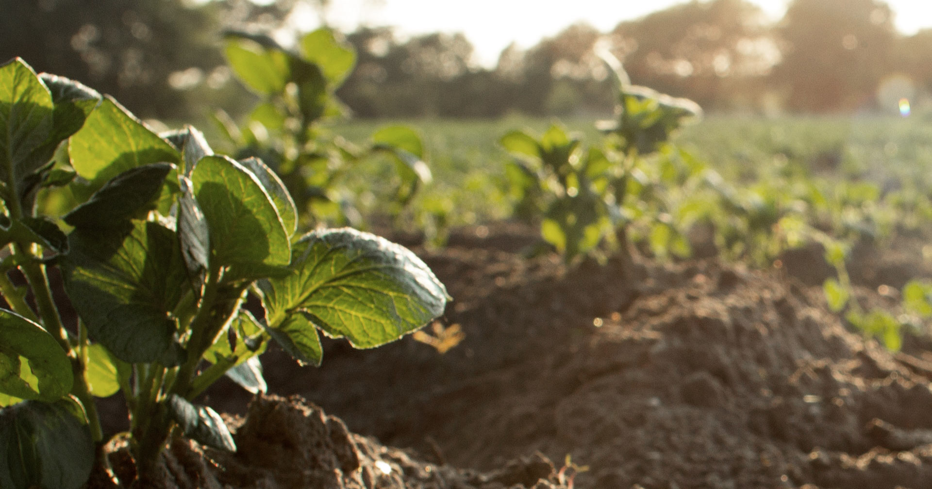
How do you choose the best location for your permaculture garden? Most people are aware that gardens, orchards and pasture have specific needs such as sun and water, but what else is there to consider to find the best location for a garden or farm on your land?
This is not that hard of a question to answer with some protracted observation and a handful of tools.
Depending on your size of your site, what follows may influence your specific site more or less than someone else, but at the least it should provide a holistic context for choosing the ideal garden spot on your land.
For example if you have a 1/4 acre back yard you may be more limited in picking the ideal spot for a permaculture garden, nonetheless there are still locations that are better than others in your backyard. Maybe the topsoil had been scraped away so there is no concern for where the best soil is BUT there are neighbors trees casting shade so getting the best sun will be important for this your site.
Other sites may be so large that the question is almost daunting to answer – where do you even begin to choose when you have 30 acres? 100 acres? This was my case – we have 30 acres where I could technically locate our permaculture farm anywhere.
There are five major natural components to look at – soil, water, sun, climate and access. In addition there are many smaller components to look at that are lumped together in a sixth component set which is your site assessment.
Where to start? A cold beer and a lawn chair is where. No joke.
Site Assessment
The task of locating a permaculture garden can be helped along by doing a permaculture site assessment.
I won’t be going into depth here as to how to do a site assessment, though I will in another article here soon, we can still review some of the land characteristics in a site assessment that we need to observe and measure. The longer you have to observe your site, the more details you will gather, the better you will do at making good decisions. Hence the lawn chair and a beer, or maybe kambucha for the non-beer drinkers.
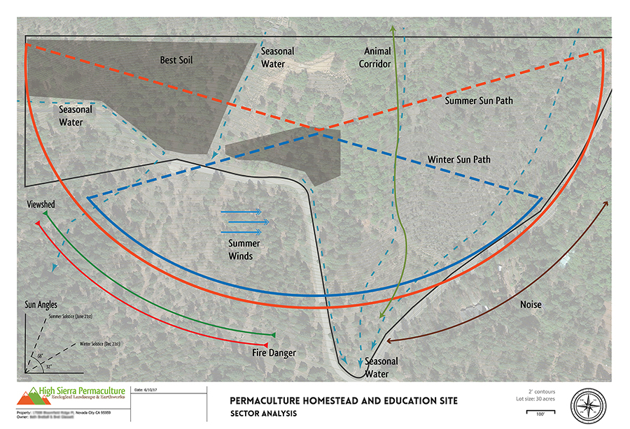
A Sector Analysis is one component of assessing a site in which you observe and map the energies, elements and forces on a piece of land in relation to the cardinal directions.
Observe everything. Take note of the winds, what direction do they come from? What time of day? What season?
Parse everything out as much as possible to get the best information you can. Examine elements over time, distance and in relation to one another if possible.
While this article is focused on the 5 primary factors to locating a permaculture garden, observation will tell you the biggest picture possible, giving you more clues than just the sun, soil and water needs that most only look for when planning a farm or garden location.
Site Observation Examples
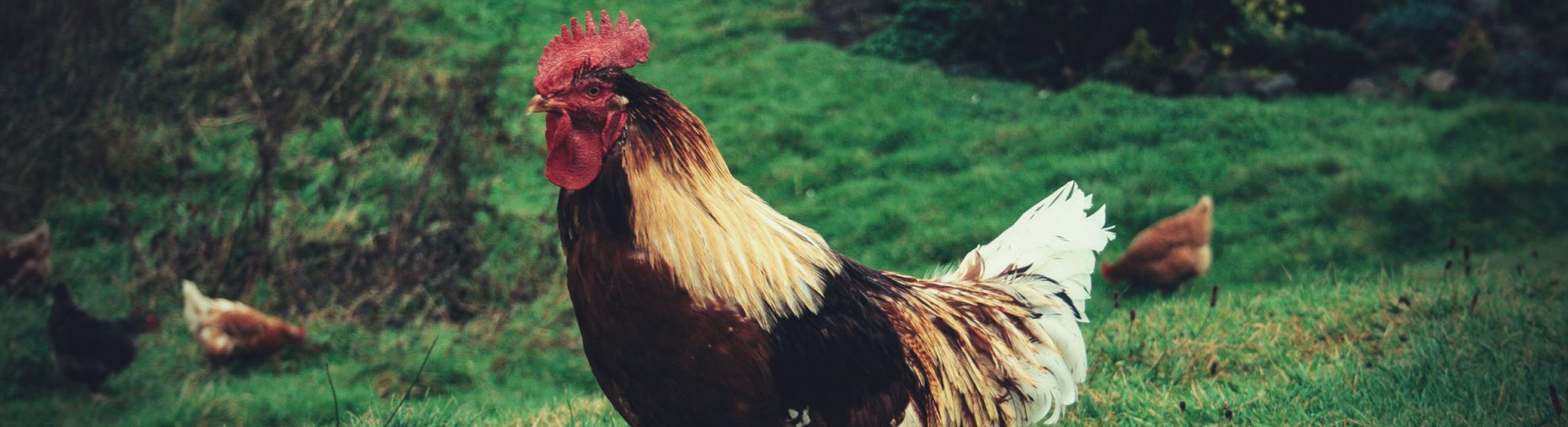
- Animals. Who is there? When?
- What plants are there? Are they healthy?
- What is the history of this area? Any visual clues?
- What direction do the winds come from? In the day? In the night?
- Is there fire danger?
- What is the slope? Is it too steep to farm? Are terraces necessary?
On our homestead, in one of the potential locations for our permaculture garden, there were a number or strange holes in the meadow with soil pushed out of them. At first I thought they were gopher holes so it seemed like a less than desirable to place a garden in the meadow area. Over the course of time, when the rains came, I got to see all of these holes were tiny springs. The water was coming out of the ground and depositing the soil around the hole!
All of these clues will help you develop an informed decision on where on you land to locate your gardens or farm.
There are many important small details to consider when choosing a location for pasture gardens or orchards, there are five elemental components that needs to be evaluated to properly choose a location. Let’s dive into them
Soil
Pretty much a no brainer here – examining your soil will be a very large clue helping you to find the appropriate location for a garden.
As it was mentioned earlier, if you have a backyard that you want to locate a garden, chances are the topsoil was scraped and it has been compacted; therefore in urban locations soil is probably of less concern. You will need to develop good soil yourself. For others who are more rural and have acreage that is relatively undisturbed, exemption here being sites that were mined, it is helpful to get a soil report and do some exploring on your site to map where the good soils are.
Soil Maps
The USDA provides an amazing free soil report tool. The USDA NRCS Soil survey tool allows you locate a parcel and generate detailed reports about the soils that were found there when the surveys were done by soil scientists in the 1970’s. Information is available for the entire United States.
The soil report will give details about the cross sections of soil and the approximate average depth of layers. It also give information about the different types of soils and their best uses.
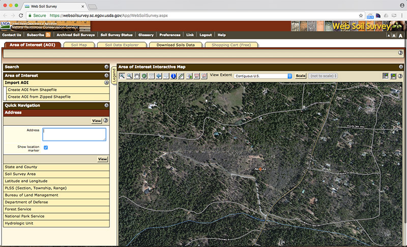
Much like topo map contour lines, these soil reports are built on averages, so you will see variances on your site in terms of the exact starting and stopping point of each soil type. In fact it is almost impossible to tell on a site as the soil blends from one to another. Nonetheless you will be able to see big picture of different types of soil on your site after creating a soil map.
Soil Tests
You can also send in samples of your soils to labs to have them tested for organic matter, minerals and nutrients. This might help narrow down the choices if there are several locations with promising soil.
Peaceful Valley Farm and Garden, located in Grass Valley, CA, offers soil testing.
Every site will be different – some will have multiple soil types other will have one. Some properties will have great soil types well suited to growing and other will have soil types better suited for other things. Even if there is a soil on your site that is superb for your needs there is still further assessment to do.
Water
Where water flows on a site can be visible plain as day, or it can be only visible certain times of the year.
It is obvious where a creek, a pond, or where a water tank is located. What you can’t always see, especially later in the middle of the summer, is where diffused surface water runs and seasonal springs surface. Being aware of surface water, diffused surface water and (stored) ground water are all important in your location decision.
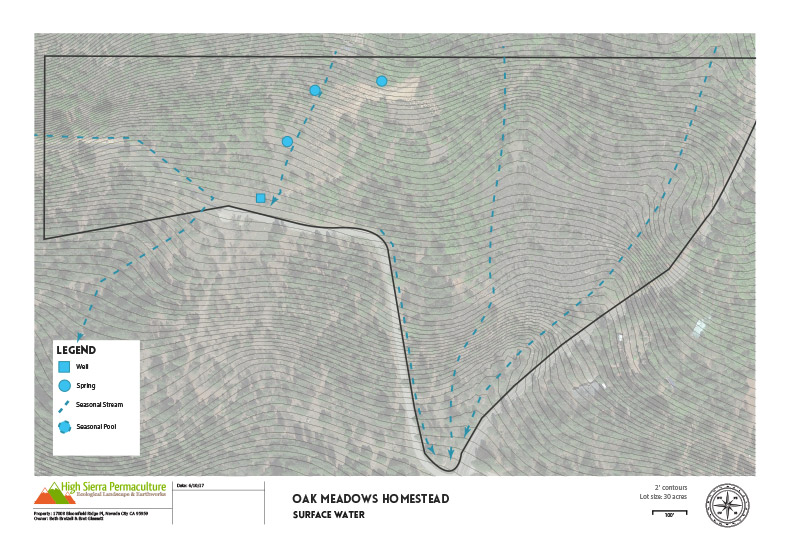
Surface Water
The traditional definition of surface waters are lakes and ponds or waters flowing on the surface of the ground in a “natural watercourse.” A natural watercourse defined as having “definite channel with beds, sides, or banks.”*
Surface water may or may not be available for your agricultural use on your land. It will depend on any water rights your parcel may come with and any local or state restrictions on taking water from waterways and diverting for agricultural purposes. Simply put a water right is a grant from the State to a party to put to use a given quantity of water. Water rights are required to appropriate any surface water of the state.
Aside from actual use on your farm or garden surface water can pose access challenges. If you have a creek between your zone 1 (your primary residence or road) and your ideal garden location, then it may be costly to develop a crossing that can support equipment, such as tractors vehicles loaded with supplies.
Diffused Surface Water
Diffuse surface water are waters that travel over the ground as a result of rain or snowmelt, but before it flows into a natural watercourse.
This water is also referred to as stormwater.*
The challenge of determining diffused surface waters impact on a potential farm or garden location is identifying where it flows when it is not present.
In late spring this can sometimes be seen as grass laid down is channels down a slope. In more severe cases it can be seen throughout the year as erosion patterns on the soil surface.The best way to see where diffused surface water runs is to observe a site for an entire year while water is present.
I am also including in this category any seasonal springs that may appear on a site as they would be treated the same as diffused surface water.
Diffused surface water is important to identify for three reasons.
First it may be available for your use in the form of water harvesting earthworks such as swales, terraces, ephemeral ponds etc. You would have to check with your local and state water restrictions to determine if you can use it. Currently in the sate of California, diffused surface water is a grey area, where some court cases have found it to fall under the same restrictions as Surface Water (therefore belonging to the State) and in other cases have found it to not belong to the Sate.
Secondly, just as with surface water, it may pose an access challenge. This is the case on our homestead – we have a wet valley meadow with diffused surface water running 5 months out of the year that a road is being built across to access the farm site. This of course requires more advances road building techniques than just dragging your farms tractors box blade around making a new road; we have to raise the road and install culverts to allow the water to flow under the road and dry the wet area out.
Third, if the diffused surface water is above your farm or garden location it may erode your precious topsoil away! With the incredible rains here in Northern CA this year (35” in 5 weeks alone this winter) we have observed additional diffused surface water that had not been here before. Two small springs popped up on the hillside just above our farmland. These were small enough that they can be captured in a water harvesting swales system to divert and harvest the water while keeping the topsoil in place in our farmland.
Ground / Stored Water
By groundwater I am meaning well water which is more than likely stored in a water tank. For anyone who is more urban this would be the same as your city water supply.
Observing where your onsite water storage and hose bibs are may help determine your garden location on a site. If you have little budget to run water pipe across a site then your garden locations might be limited to where water is within reach of a small poly tube water system. If you do have the money to develop water delivery infrastructure, then your options may be more open. If so take into account the difficulty of trenching and laying water lines to the potential farm or garden locations.
I am neglecting other sources of water, such as grey water and roof water catchment, as it is often not enough water to make or break a garden or farm location. That said it is of course important and in some instances should be taken into consideration when identifying your best garden or farm spot.
Solar Access
The direction of your lands slope, or aspect, dictates a lot of your locations ability to get good sun exposure.
Sun exposure is of course mandatory for all plants to grow – and for most agricultural endeavors having full sun is a must.
North slopes (in the northern hemisphere) get the least amount of sun whereas south facing slopes get the most sun. East and West are some degree in between. For most farms and gardens you will want the ability to have as much sun as possible.
After slope aspect, structure and trees that block sunlight are next to look at. In most cases you probably can’t remove a structure and you need to plan around them. Trees however, especially if rural, and not on your neighbors land can be removed or high pruned for increased sun in a site.
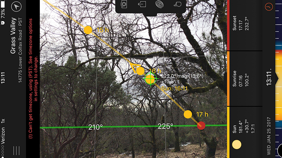
There are many tools such as the Sun Surveyor App that allows you to look at the suns path on any day or time of the year through the camera. With this you can see any potential obstruction that might reduce sun on a spot. I tend to look the solstices for spring, summer and fall to get an idea of the sun available in a location.
Note that you can also leverage this to keep shade.
You can use this tool to intelligently locate beds that are growing plants that do not want full sun. You can also selectively clear a landscape, opening up spring and winter sun but leaving a bit of shade in the hottest parts of the late summer evenings.
Climate
All sites have different microclimates even if the differences are subtle. Larger sites tend to have more obvious climates but the overall principle of looking at micro climates applies to both.
For example cold sinks. These are low spots, such as valleys, that tend to be colder than higher up on the hillside. Depending on your crop this may be a good or a bad thing. Fruit trees require a certain number of chill hours per winter and in really hot locations a cold sink might help this out. Conversely in colder regions this cold sink will frost more often so planting your annual garden may not be ideal there.
The goal is to play the micro climates to your advantage as much as possible. In doing so you will reduce your “fight” against nature and tend to reduce time and money invested into a garden or farm.
Microclimate Clues
- Temperature
- Moisture
- Wind
- Aspect (direction)
- Vegetation
Access
Access is how easy (or hard) is the potential garden or farm location to access both on foot and with a vehicle or equipment.
You will want to ensure a vehicle can get to the garden to bring in heavier supplies such as compost and mulch. In some cases, a tractor will be used on the farm, so ensuring the access is able to support the weight of the equipment is important.
As discussed earlier in the water section, consider if you need to develop a road to the farm or garden, how difficult it will be to develop. How much soil would need to be displaced? Will fill material need to be brought in? Are you needing to install culverts for drainage under the road? Does it need to be permitted?
In addition to roads there might be wheelbarrow or walking paths that are shorter routes between outbuildings and the gardens on your site. Can these be developed with ease? Can they be on or close to a contour line (Keyline Planning) for easy walking?
Looking at the frequency of access is another factor in determining location. Bill Mollison in his Permaculture A Designers Manual, advocates that soil can always be built, therefore you should consider your gardens location to zone 1 (your primary residence) as paramount. I feel there are can be exceptions to this.
On our homestead, the gardens are located about 700’ away from our house, as there were many factors that outweighed placing the gardens closer to the house. Of course we weighed this heavily and checked our sacrifices by timing the walk, timing the drive by tractor and factoring how much time per year we might loose going back and forth between the house and the gardens during the growing season.
How do you begin determining what is the best location for your farm or garden?
While every site is different you can follow these steps to figure it out. This is where you need to summon all your assessment skills, go on your site to observe, and record your findings. Your reward is hopefully the best location on your land for a farm or garden
First you need to outline your specific needs.
You may not know the exact plants you are wanting to grow but you should have an idea that can be used to estimate, such as growing annual vegetables and staple crops or pasture for grazing.
Second you need to take your site assessment and your observations on the soil water, sun and access to identify a handful of locations, and outline the strengths and weaknesses of each.
Take a piece of paper and draw two columns.
Write your desired site elements, such a garden beds, orchard, pasture, rice paddy etc in the first column. In the second column list out your site locations you identified. Now based off the strengths and weaknesses of the locations and the needs of your site elements draw lines connecting them based of how they fit each other. Note that there may be more than one relationship possibility. Also note that in the real world, your site elements might not have hard edges, such as your orchard bending into the top and sides of a garden around the beds.
Stumped?
Wow, that is a lot to take in for just figuring out where to just put a friggin’ kale bed, right? I would like to hear your struggles, questions or difficulties surrounding this. Leave a comment and I’ll respond. Who knows maybe your question will help someone else.


I grew up on well water and it was great! Thank you for the article!
Very informative article.
Samantha
http://gardening-directory.com/
What software are you using to create your sector analysis?
Mostly Adobe Illustrator though the topographic information sometimes comes from GIS software.